
Route: Vereda da Ponta de São Lourenço
Area: Madeira
Date of walk: 27th January 2025
Walkers: Andrew and Gilly
Distance: 3.2 miles
Ascent: 1,100 feet
Weather: Sunny and warm
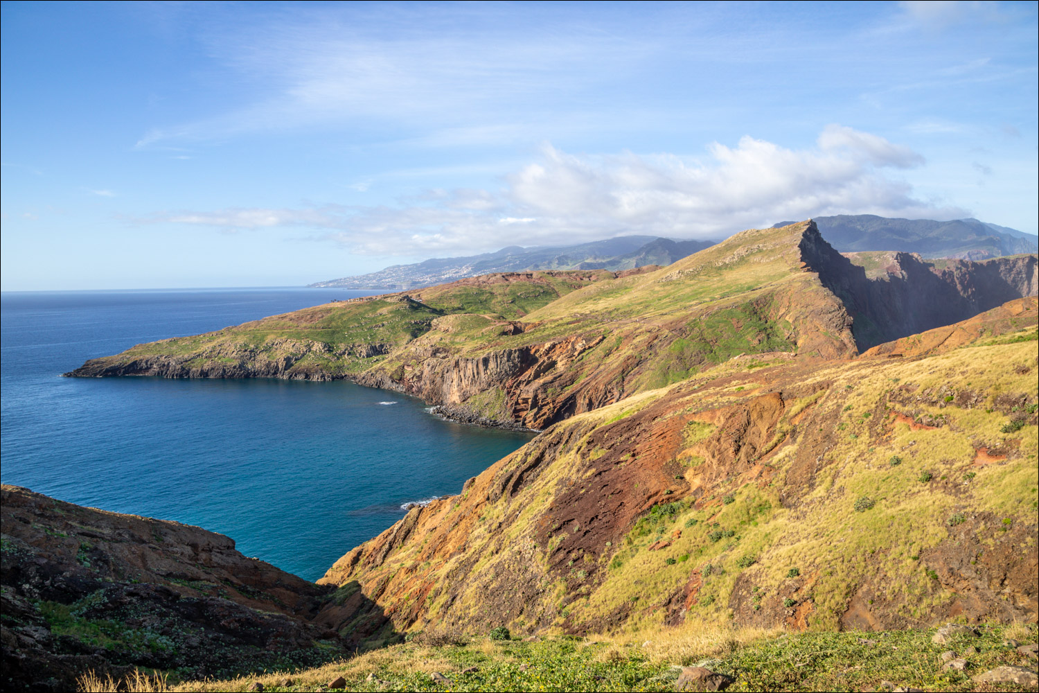
Today’s walk was at the top of our list for our stay in Madeira. It’s best saved for clear conditions and today was such a day. The route is a popular one and so we set off early and parked in one of the many roadside spaces near the start of the walk. From here we had a good view of our destination, the peninsula of Vereda da Ponta de São Lourenço. The semi-arid climate and exposure to northern winds explain the low vegetation and the absence of trees in this place, contrasting with the rest of the island. The peninsula is classified as a Partial Nature Reserve heritage site and is home to rare plants. 138 species have been identified here, 30 of which are endemic to Madeira
On reaching an information panel at the start of the walk, we were asked to pay an entrance fee of 3 euros per person. We hadn’t read about this before, but no doubt it helps to preserve the site. We then set off along the peninsula – there’s no chance of getting lost on this walk, the obvious path runs along the narrow peninsula with numerous ups and downs. The cliff top views were wonderful and got better and better the further we went
At the mid point of the walk we crossed a natural land bridge, the narrowest section of the peninsula, with 100 metre drops on either side down to the sea. The path is well protected and there are no dangers. Near the far point of the walk we talked to a couple of representatives of Madeira Sea Emotions, which opened up an interesting way of returning to the start. Instead of retracing our steps, which had been our plan, we decided to take the boat back to the start. There was an hour before the next sailing and so we continued along the peninsula, passing by the cafe at Caso do Sardinha, before making a short but tiring climb to the highest point of the walk at Furado. The views from here were amazing. We then retraced our steps to a small cove to await the boat. This proved to be an adventure in itself as we were taken on a tour to the very end of the peninsula which cannot be accessed on foot. After a very bumpy and exciting ride in an inflatable speedboat we arrived in Caniçal Marina. From here it was a 1 mile walk back up the road to the end of what had been spectacular walk
Click on the icon below for the route map

Scroll down – or click on any photo to enlarge it and you can then view as a slideshow

Having paid our 3 euros, we set off along the Vereda da Ponta de São Lourenço ("Path of the Point of Saint Lawrence" in Portuguese)

The first of many ups and downs along the way

Porto Santo in the distance, the smallest inhabited island of the Madeira Archipelago

Looking along the São Lourenço peninsula, with the bay known as Baía d'Abra below

The path below leads down to a rocky beach, but we will keep to the higher path as it passes around the cliffs

The lower path and Baía d'Abra again

We keep to the higher path at the junction

Spectacular scenery on the other side of the peninsula...


We approach a cliff wall

Zooming in on a couple of walkers - the path looks a little daunting seen from here, but it's perfectly safe

We walk down to a viewpoint on our left

Looking out across the Atlantic Ocean

Spectacular red volcanic cliffs...


Looking back as a lone walker follows the path we'd taken earlier (which was perfectly safe despite appearances from here)

Looking back, we can just make out the car park at the start of the walk, mid left of picture

More views back along the route...


Porto Santo in the distance

We cross a natural land bridge, the narrowest part of the peninsula, with 100 metre drops down to the sea. Sturdy fencing provides comfort along this section...


Looking along the cliffs


The far point of the walk ahead


We arrive at a small cafe, Caso do Sardinha...


Beyond the cafe we make a short there and back climb to a spectacular viewpoint


This is the end of the road for walkers, further progress along the peninsula isn't possible

We retrace our steps back down to Caso do Sardinha...


A final look back to the far point of the peninsula, where we can just make out the lighthouse

Our original plan had been to walk back to the start, but we decided that it would be fun to take a boat back instead

We await the boat, which turned out to be a small 'rib'. The camera had to be stowed away as we made an extremely bumpy ride below the cliffs as far as the lighthouse and then back to the mainland

We disembark at the small harbour in Caniçal, and from here we had to walk along the road for about 20 minutes to reach the car park and the end of a memorable walk
