
Route: Munkebu
Area: Norway, Lofoten Islands
Date of walk: 31st July 2017
Walkers: Andrew and Gilly
Distance: 5.9 miles
Ascent: 2,100 feet
Weather: Sunny and warm
During the morning we’d driven 40 miles or so to our next base in the Lofoten Islands, in the village of Reine – and what a wonderful drive it was, full of interest all the way. The cloud base had been quite low however, covering all but the bases of the surrounding mountains, and we wondered if our planned high level walk would lack the advertised views. We decided to carry on with the plan and if we walked into mist we could always turn back
We parked in Sørvågen and after following a track for a short distance climbed up some smooth rocks to reach two lakes, both set in stunning positions. As we gained height above the lakes we encountered a particularly steep section where chains were provided, and using these we managed to haul our ageing bodies up the rocks
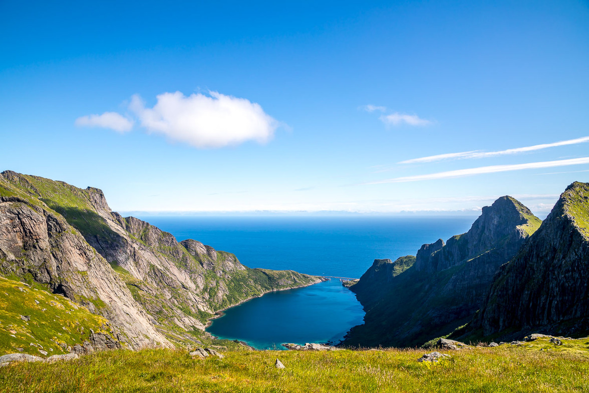
By now the clouds had lifted giving way to some glorious weather. After more climbing we eventually reached a col from which there were amazing views down two valleys – one down Djupfjordheia towards the sea, and the other back down our route, past the lakes, and out to sea. From the col it was a short climb to the high point of the walk, Munkebu at approximately 1,700 feet, and from here the view was simply breathtaking. The walk continues to the Munkebu cabin which we could see in the distance, but as this involved a descent and re-ascent back to the summit we gave it a miss and retraced our steps down to the col
From here we walked along a grassy path with sheer drops to our left but the path was some distance from the chasm and there was no sense of exposure. We followed the ridge downhill, admiring yet more sensational views, and then clambered down a final steep rocky section through birch trees before rejoining our original ascent path
It had been an incredible walk, ranking among the best we’ve ever experienced, and we felt lucky to have enjoyed it in such good conditions
Click on the icon below for the route map
![]()
Scroll down – or click on any photo to enlarge it and you can then view as a slideshow

We bid farewell to the rorbu at Mortsund, our base for the last 3 nights, to continue our Journey to Å

Driving south, we cross the Hamnøy Bridge and stop to admire the view of the Eliassen Rorbuer...


Dried cod's heads - the fish is the staple diet of the islands, and there's a market for the dried heads in Nigeria where they are used in traditional Nigerian cooking

A short while later, after parking in Sørvågen we set out to climb Munkebu, which lies directly north of the village

Looking back over the local lake, Sørvågvatnet

Another view back as the weather starts to improve

A series of cascades as we gain height

We arrive at another lake, Stuvdals

Our path takes us along the eastern shore of the lake


The path rises above the lake


Looking back over Stuvdal Lake...


A steep rocky section where chains assist us in overcoming gravity

A small cairn at the end of the rocky section

We continue to follow the rough path uphill

Waterfall flowing out of a smaller lake named Tridals


Tridals Lake


Tridals Lake again

Looking back to Stuvdal Lake

Cairn above Tridals Lake

Another view back to Studval and the sea beyond

We continue over rocky moorland towards a small plateau

View of mainland Norway from the plateau - our return route will take us along the back of the peak on the right, but thankfully a safe distance away from the crags

We'd driven across the bridge below earlier


We arrive at the highest point of the walk at approximately 1,700 feet. It's possible to continue from here to Munkebu cabin, which involves a down and up, but we decided to return at this point

Summit cairn on Munkebu

We retrace our steps back to the col...

...and then head across the back of the mountain in the foreground

This was a wonderful section of the walk, with dramatic views in all directions

After an initial climb, the path levels out

Looking across to Tridals Lake, which we'd passed by earlier at lower altitude

A view back along the path


We pass by this oddly shaped rock outcrop

Walking above Stuvdal Lake

We continue to follow the line of the ridge

The path then descends quite steeply back down to Stuvdalsvatnet

The end of the walk as we reach Sørvågen and its lake again

We then drive to our nearby base for the next two nights - the Reine Rorbuer, set in a wonderful position on a small peninsular


Fish drying racks

The former police house, now divided into three apartments - we are staying in Jesper

The end of a grand day
