
Route: Loweswater and Holme Wood
Area : Western Lake District
Date of walk: 26th July 2023
Walkers: Andrew and Gilly
Distance: 5.7 miles
Ascent: 1,000 feet
Weather: Mostly sunny
This is one of my favourite local walks which, in the space of 6 miles, manages to cram in a huge variety of scenery including farmland, ancient woodland, a lake, a tarn, open moorland and a lonely valley. Along the way there are wonderful views over the Solway Plain looking north (including Scotland in clear weather) and to the high lakeland fells looking south
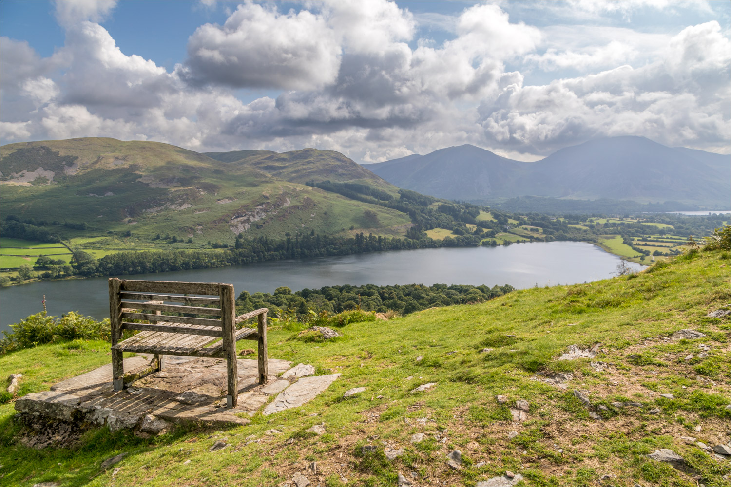
It’s been nearly one year since I followed this route, an absence caused by a dodgy knee. I hoped that its replacement would be up to the task, the longest walk I’ve undertaken since the operation in February. We made an early start and parked as usual at Maggie’s Bridge where there is space for 8-10 cars. Instead of heading directly to Loweswater we followed the track to High Nook Farm, where Alfred Wainwright used to stay when he was researching his Guide to the Western Fells. After passing through the farm we carried on to the head of the valley before joining the wonderful terraced path above Holme Wood, known as the old coffin road from Loweswater to St Bees (the description may be fanciful but the name has stuck). The views from here are superb, especially those from a well sited bench
The path contours around the sides of Carling Knott and Burnbank Fell and reaches a height of over 1,000 feet – higher than one or two lakeland fells. However the climbing is so gentle that it’s hardly noticed. There is a shorter alternative for anyone who is tiring, click here for more information. As it was, my knee was holding up and so we carried on towards Fangs Brow, on the very edge of the Lake District, before turning back at Iredale Place and following the path past Jenkinson Place and Hudson Place
We then descended into Holme Wood, and along the shore of Loweswater, passing by the bothy along the way
The last section was an easy stroll along the track between Watergate Farm and Maggie’s Bridge, passing through recently established traditional hay meadows in some of the fields, which will add to the delight of the walk in years to come
For other walks here, visit my Find Walks page and enter the name in the ‘Search site’ box
Click on the icon below for the route map (subscribers to OS Maps can view detailed maps of the route, visualise it in aerial 3D, and download the GPX file. Non-subscribers will see a base map)

Scroll down – or click on any photo to enlarge it and you can then view as a slideshow

A few days before the walk, a stoat in the garden...

...and a red squirrel

The start of the walk from Maggie's Bridge as we follow the sign to High Nook Farm

Carling Knott and Holme Wood on the right. Our route will contour around the fell at mid-level and take us above the wood

Looking back to Low Fell

Having passed through High Nook Farm we continue up the valley

Looking back to Low Fell and Lorton Vale

High Nook Tarn is ahead, out of sight, and before reaching it we turn sharp right

We cross the bridge over Highnook Beck and start the climb along the lower flanks of Carling Knott

We follow the easy path towards the edge of Holme Wood

Looking back to Hen Comb and the path we'd followed at the foot of Gavel Fell

A glimpse of Crummock Water as we reach the edge of Holme Wood

We follow the terrace path above the edge of Holme Wood

Loweswater through the trees, which have recently been thinned out, as the larches have been affected by Ramorum disease


The walk may be shortened here by entering Holme Wood via this gate

We ignore the shortcut and continue at higher level, crossing the footbridge over Holme Beck

Loweswater below, with Whiteside and Grasmoor in the background

We contour around the flanks of Burnbank Fell

The Bench, which commands a wonderful view over Loweswater (see the panorama at the end for a wider view)

Loweswater and Darling Fell

The head of Loweswater below - the lake is unusual in that it drains into lakeland and not out of it, as would be expected

Looking back to Loweswater and Crummock Water


On the northern fringe of the Lake District now, as we head towards Fangs Brow

Just before Fangs Brow we leave the path and turn right at the sign for Hudson Place

Start of the return leg

We pass above two traditional lakeland farmhouses - Jenkinson Place...

...and Hudson Place

We descend towards Loweswater

A rare breed sheep in the fields

On reaching Loweswater we make a short diversion to the shore


We return to the main track and cross Holme Beck for the second time (there's a footbridge to the right in case the beck is in spate)

Loweswater

At Watergate Farm we join a track which takes us back to the start...


Grasmoor and Mellbreak ahead, and the end of the walk is just around the corner
