
Route: Lingmoor Fell
Area: Southern Lake District
Date of walk: 31st August 2024
Walkers: Andrew
Distance: 5.3 miles
Ascent: 1,350 feet
Weather: Sunny, very warm and very hazy
The weather in the Lake District has been dreadful this year, especially in August when it’s rained almost every day. A favourable forecast for the last day of the month prompted me to plan a return to Lingmoor Fell, which I haven’t visited for over four years. On my earlier walks I’ve always started from Elterwater (click here for this longer version of the walk), but I decided instead to make a start from Blea Tarn. After an interesting drive along very minor roads I arrived at the National Trust car park at Blea Tarn, which most people use to visit the nearby tarn, set in a heavenly position. Lingmoor Fell has two main attractions – a rollercoaster dry stone wall which runs along its undulating ridge, and the views of the Langdale Pikes. This is probably the best place in the district from which to see them. Lingmoor Fell is renowned for its beautiful green slate and has been extensively mined for it – evidence of this is abundant on the early section of the walk
I headed south along the very narrow lane known as Side Gates, leaving it just before a junction to follow a path which I’d identified on the OS map but had never walked before. This proved to be a mistake and it was tough going through high bracken and brambles. The path was very overgrown and I can’t recommend it, except possibly in winter and early spring. I suggest that anyone following this walk in late summer or early autumn plots an alternative course to the foot of Lingmoor Fell, either by walking along the lane in Little Langdale or following the path beyond Little Langdale Tarn which crosses Slater Bridge
After battling my way through the undergrowth it was a relief to arrive at the stony but well used path up Lingmoor Fell. As I continued to ascend there were views back to Windermere, but the light was poor for photography and the long distance views were very hazy. I crossed a stile to reach the summit of Lingmoor Fell, marked by a stone cairn. The best part of the walk is the descent from the summit with ever improving views of the Langdale Pikes, Bowfell and Crinkle Crags. There are several rock steps on the way down, and these require the use of hands at times. However there are no dangers
The Lingmoor Fell ridge ends abruptly at Side Pike, which lacks the height to be classified as a ‘Wainwright’ but it’s an impressive fell nonetheless. At the foot of Side Pike I turned left to follow a path down to Side Gates. It would be shorter to turn left here and stroll along the lane back to the car park, but I decided to turn right instead and make a circuit around Blea Tarn. This brought me back to the start of a superb walk, though one point has to be deducted on account of the overgrown path above Little Langdale Tarn
For other walks here, visit my Find Walks page and enter the name in the ‘Search site’ box
Click on the icon below for the route map (subscribers to OS Maps can view detailed maps of the route, visualise it in aerial 3D, and download the GPX file. Non-subscribers will see a base map)

Scroll down – or click on any photo to enlarge it and you can then view as a slideshow

The start of today's walk as I turn left out of Blea Tarn car park and walk towards the head of Little Langdale, with the Tilberthwaite Fells beyond

Looking across to Wetherlam

Looking back to the road from the start of the path along the foot of Lingmoor Fell

Another view back along the path as it became more overgrown and choked with bracken and brambles. In retrospect it would have been better to walk along the Little Langdale road below

Looking across to the Coniston Fells - Wetherlam, Swirl How and Great Carrs

I pass above Little Langdale Tarn

After battling my way through the bracken it was a relief to arrive at the path leading up to Lingmoor Fell. I turn left just before this gate

A view back to the Coniston Fells and Little Langdale Tarn

A hazy view of Chapel Stile in Great Langdale on my right

Further up the heather clad slopes of Lingmoor Fell

A hazy view of Windermere looking back

A well constructed stone bench near one of the old slate quarries

I follow the path beside the rollercoaster dry stone wall

Pike o'Blisco, Crinkle Crags and Bowfell as I approach the summit

I cross a stile to visit the summit cairn on Lingmoor Fell

Looking towards Bowfell from the summit of Lingmoor Fell

Wonderful scenery ahead as I start the descent and follow the line of a dilapidated dry stone wall

Great Langdale below

The Langdale Pikes dominate the scene, L to R - Pike o'Stickle, Loft Crag, Thorn Crag, Harrison Stickle and Pavey Ark

Blea Tarn below - my return route will take me along the back of it and then to the car park which is on the left of the picture

Side Pike ahead

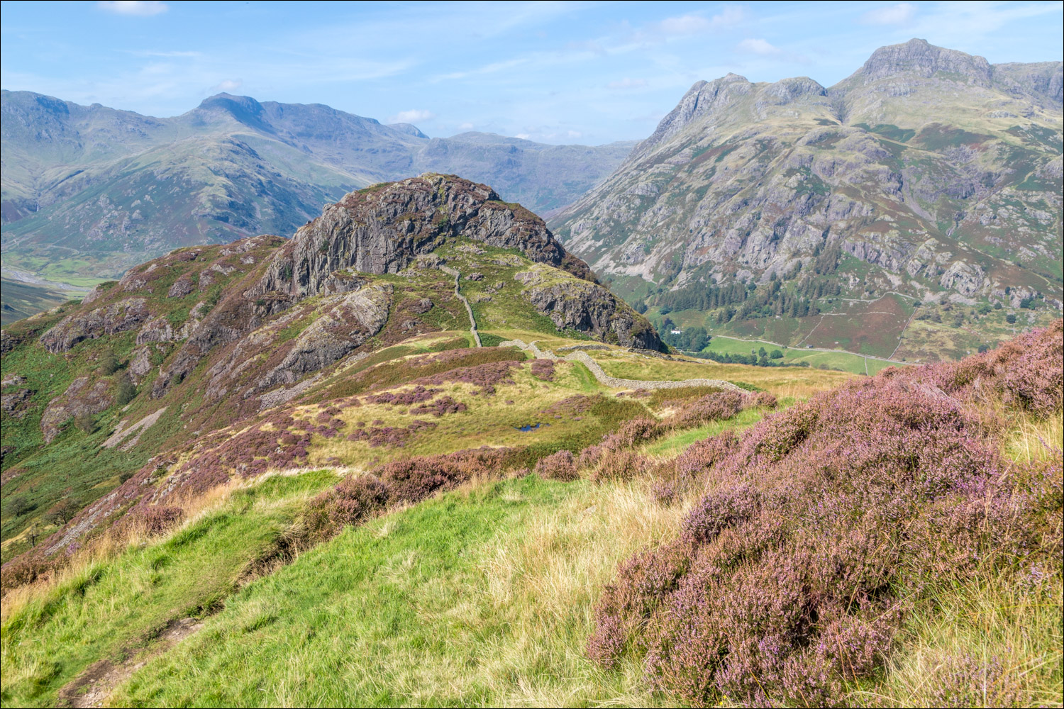
Beyond Side Pike, a wider view including Crinkle Crags, Bowfell and the Langdale Pikes

I pass through this gate, beyond which lie a few steep rocky sections

More views of Side Pike and the Langdale Pikes as I continue to descend...


At the foot of Side Pike I turn left to descend into the valley

Blea Tarn - my path will take me around the back of the tarn

The route could be shortened here by turning left along the road below, which leads directly back to the Blea Tarn car park

I chose to turn right in order to include Blea Tarn in the itinerary

The road continues into Great Langdale, and I turn left just beyond these gates

I follow the path to Blea Tarn...

Lingmoor Fell is on the left


I cross the footbridge over Bleamoss Beck


The Langdale Pikes from Blea Tarn

Looking across to the Langdale Pikes and Side Pike as I follow the path from Blea Tarn back to the car park
