
Route: La Chapelle d’Abondance
Area: Chablais Alps, France
Date of walk: 17th August 2018
Walkers: Andrew and Gilly
Distance: 9.8 miles
Ascent: 2,700 feet
Weather: Sunny at first then clouding over with rain and thunder
Today’s walk would be a linear one from Abondance to our next hotel further along the valley in La Chapelle d’Abondance. A gentle meander along the valley floor is possible, but we decided to opt for a high level route around the spectacular Mont Chauffé via the Col d’Ubine. Thanks to Inntravel our bags would be transported via taxi and would await us when we reached our destination
We set off early, as rain was forecast in the afternoon, and walked out of Abondance past the old abbey following the road uphill. After a short while we turned off up a stony track which took us up through the forest. The varied but easy climb took us over the Col de la Plagne into the beautiful Ubine valley, dominated by the huge rock face of Mont Chauffé. The section along the valley up to the Col d’Ubine was the scenic highlight of the walk. As we headed up to the col we could hear the sound of thunder rumbling in the distance, but ominously getting louder the higher we went. We quickened our pace, as we were aware that the descent from the col is steep and potentially slippery when wet
Beyond the col we traversed the mountainside and were lucky to have passed the most difficult section before rain started to fall, quite heavily at times. When we reached Chalet de Mens we started a long but very easy descent to our destination – the Hotel les Gentianettes in La Chapelle d’Abondance – where it was a relief to change into dry clothes. It had been a fantastic walk despite the rain on the descent
Click on the icon below for the route map
![]()
Scroll down – or click on any photo to enlarge it and you can then view as a slideshow

Another lovely day as we look out of our bedroom window and start our high level journey from Abondance to La Chapelle d'Abondance further along the valley

We make an early start, as rain is forecast in the afternoon, and pass below an arch

We pass by the abbey

A short road section as we head up out of Abondance

Looking back to Mont Grange

At Combafou we leave the road to follow a stony track uphill

We follow a narrow path through the forest

Looking back down to the valley from a gap in the trees

We emerge onto the road again and continue uphill

Looking back over the valley to Mont Grange

A Six Spot Burnet moth

Looking along the Abondance valley in the direction of our destination - but our route is a circuitous one, and leads us uphill and around the back of the mountains to the left of the photo

We arrive at La Plagne du Mont at 1,370 metres, or 4,500 feet

We pass beside an old wooden chalet in the meadow

Looking up to the Mont Chauffé ridge - our route will take us around the far side and back down into the valley

We join a forest track at 1,483 metres

Looking back as we follow the track uphill

The Abondance Valley comes into view through a gap in the trees

From Col de la Plagne, a glimpse of Mont Chauffé, and a hint of things to come

A woodland section as we head towards the cliffs of Mont Chauffé...


We emerge from the woods to our first clear view of the dramatic rock face of Mont Chauffé ...


Our path leads us down to the hamlet of Ubine below, before we ascend to the col at the foot of the cliff...


View to our left as we approach Ubine

We walk past the chapel in the hamlet of Ubine

Looking back over Ubine as we head up to the Col d'Ubine...


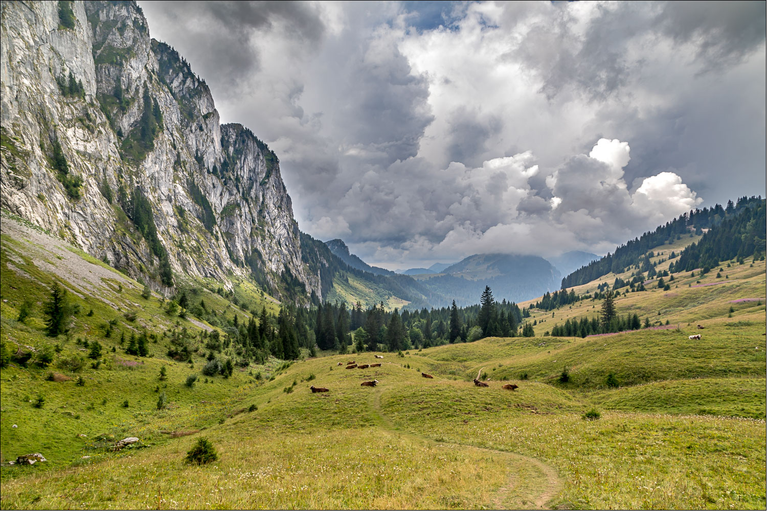
The cliffs of Mont Chauffé tower over us as we head up to the col...


Looking back down the valley as we pass through a herd of alpine cattle...


We could hear the sound of thunder in the distance, becoming louder as we progressed, and we stepped up the pace here as we'd read that the path is potentially difficult when wet

From the Col d'Ubine, Les Cornettes de Bise at almost 8,000 feet

We start the long descent from the col

Les Cornettes de Bise again

Having rounded the cliffs of Mont Chauffé we continue our descent, and it starts to rain at this point, gently at first but gradually becoming heavier

Luckily the steepest part of the descent is behind us by this stage


The camera had to be stowed away for most of the descent, as the rain became heavy at this point, and didn't relent

A woodland section as we continue down into the valley

We arrive at our destination - La Chapelle d'Abondance...

...where we had a warm welcome at our next hotel, Les Gentianettes
