
Route: King’s How on Grange Fell
Area: Central Lake District
Date of walk: 4th June 2022
Walkers: Andrew and Gilly
Distance: 3.5 miles
Ascent: 1,100 feet
Weather: Sunny
Grange Fell is a lowly fell but what it lacks in height it makes up for in beauty, being set in the heart of Borrowdale, one of the loveliest valleys in the Lake District. It’s a superb craggy little fell with three separate widely scattered tops – Ether Knott, Brund Fell and today’s destination King’s How. We parked in the National Trust Bowderstone car park and from here followed a path which goes through ancient woodland, which is classified as temperate rainforest. The woodland path gradually curves around the steep crags above – a direct assault on the fell would be impossible for ordinary walkers
After walking through Cummacatta Wood we arrived at the steep rocky staircase which leads to Long Moss near the summit of King’s How. From the summit there is a superb view over Derwent Water looking one way and Borrowdale looking the other
A direct descent from the summit is out of the question thanks to the crags on the west, so we followed a narrow path which snakes round the other side of the fell and which descends steeply, eventually ending at the Borrowdale road. We followed the road for a short distance – there’s a narrow footpath most of the way – then crossed over at the sign indicating the Bowderstone. We followed this path through the woods, past the massive Bowderstone and back to the car park
For anyone following this walk, I’d mention that although the route is only 3.5 miles long, it is likely to take as much time as one twice its length. It’s best to set aside a full morning or afternoon. The terrain is rocky and complicated and there are very few sections where it’s possible to get into a proper stride. Walking poles are a very useful piece of kit to bring along
For other walks here, visit my Find Walks page and enter the name in the ‘Search site’ box
Click on the icon below for the route map (subscribers to OS Maps can view detailed maps of the route, visualise it in aerial 3D, and download the GPX file. Non-subscribers will see a base map)

Scroll down – or click on any photo to enlarge it and you can then view as a slideshow

The start of the walk as we leave the Bowderstone car park

We follow a path through Cummacatta Wood, classified as temperate rainforest

Looking back to Castle Crag

A marshy area ahead, where we spotted over 20 of the rare and endangered Marsh Fritillary butterflies...


Another view back to Castle Crag, one of the 'Jaws of Borrowdale', our destination, King's How, being the other

Looking across to High Spy

Greatend Crag on Grange Fell, illustrating why our route approaches the fell via the back door

An important junction which is easily missed - it’s tempting to continue through the wall gap below Grange Crags, but we turn right here to join a fainter path leading steeply uphill

We follow the path through the woods, consisting of a steep rocky staircase in some places

Derwent Water and Skiddaw seen though a gap in the trees

The gradient eases as we climb out of the woods

We arrive at a small boggy plateau known as Long Moss, just below King's How. There are 2 or 3 paths on the right all of which lead up to the summit

Derwent Water and Skiddaw as we arrive on the summit ridge

King's How ahead. This is one of the three tops on the complicated expanse of Grange Fell, the other tops being on the left of the picture

Looking across Grange Fell to its other tops, separated by Long Moss below

Derwent Water and Skiddaw from the summit of King's How

Castle Crag and its surrounding woodland

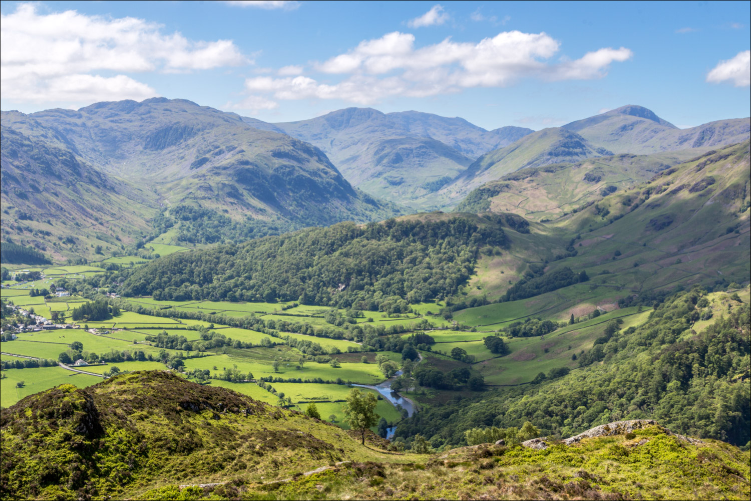
Borrowdale in all its glory

Jopplety How and Brund Fell

The start of a heavenly descent, one of the very best, with views into the heart of Borrowdale. This is one of the reasons why the route is best followed clockwise, as described, in order to keep these scenes ahead...


We aim for the dry stone wall below

We pass through the wall gap, with the River Derwent below...


Borrowdale birches as we descend into the valley...


We follow a path through the woods which meets up with the path from Watendlath, and will turn right on reaching it

A final view of Borrowdale

We arrive at the valley road. There's no satisfactory path back to the start from here, so a short road section follows

We follow a narrow path beside the road, keeping a sharp lookout for a path on the right, signed for The Bowderstone

Having located the path, we pass by the famous Bowderstone

It's a short stroll from the Bowderstone back to the car park, and the end of a walk which will live long in the memory thanks to those views over Borrowdale....
