
Route: King’s How on Grange Fell
Area: Central Lake District
Date of walk: 29th September 2021
Walkers: Andrew
Distance: 3.5 miles
Ascent: 1,100 feet
Weather: Mixed sun and cloud, some light rain
Grange Fell is a lowly fell but what it lacks in height it makes up for in beauty, being set in the heart of Borrowdale, one of the loveliest valleys in the Lake District. It’s a superb craggy little fell with three separate widely scattered tops – Ether Knott, Brund Fell and today’s destination King’s How. I parked in the National Trust Bowderstone car park and from here followed a path which goes through ancient woodland, which is classified as temperate rainforest. The woodland path gradually curves around the steep crags above – a direct assault on the fell would be impossible for ordinary walkers
After walking through Cummacatta Wood I arrived at the steep rocky staircase which leads to Long Moss near the summit of King’s How. From the summit there is a superb view over Derwent Water looking one way and Borrowdale looking the other
A direct descent from the summit is out of the question thanks to the crags on the west, so I followed a narrow path which snakes round the other side of the fell and which descends steeply, eventually ending at the Borrowdale road. I followed the road for a short distance – there’s a narrow footpath most of the way – then crossed over at the sign indicating the Bowderstone. I followed this path through the woods, past the massive Bowderstone and back to the car park. During the course of the walk I didn’t see another soul until I arrived back near the start
For anyone following this walk, I’d mention that although the route is only 3.5 miles long, it is likely to take as much time as one twice its length. It’s best to set aside a full morning or afternoon. The terrain is rocky and complicated and there are very few sections where it’s possible to get into a proper stride. Walking poles are a very useful piece of kit to bring along
For other walks here, visit my Find Walks page and enter the name in the ‘Search site’ box
Click on the icon below for the route map (subscribers to OS Maps can view detailed maps of the route, visualise it in aerial 3D, and download the GPX file. Non-subscribers will see a base map)

Scroll down – or click on any photo to enlarge it and you can then view as a slideshow

The start of the walk as I enter Cummacatta Wood from the Bowderstone car park, here looking across Borrowdale to Nitting Haws

The first section of the walk takes me through ancient Borrowdale woodland, classified as temperate rainforest...


Looking back to Castle Crag

Bracket fungus on a birch tree

The ridge between High Spy and Maiden Moor...


Castle Crag below High Spy

High Spy

Greatend Crag below King's How and Grange Fell, illustrating why a direct ascent of the fell is not possible

I continue through Cummacatta Wood...

Autumn colours are beginning to show

Black Crag

The path up to King's How is easily missed and is located just before this wall gap

After a short but steep climb, mostly up a rocky staircase, I arrive at a flatter area below King's How

A view north along the crags

I walk around the edge of Long Moss, a marshy area below the summit

High Spy and Maiden Moor on the far side of Borrowdale

I arrive on the ridge leading to the summit, looking back to this fine view of Derwent Water

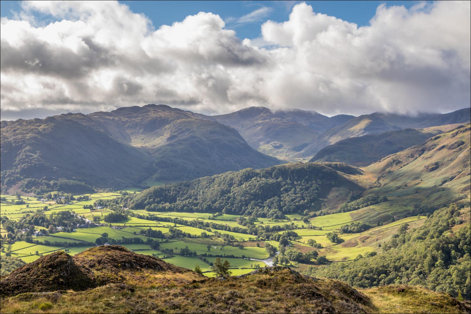
Borrowdale from the summit of King's How on Grange Fell

Derwent Water and Skiddaw from the same spot

Looking across the complicated and knobbly summit area of Grange Fell

The start of a heavenly descent into Borrowdale

Castle Crag, which looked so imposing at the start, now looks insignificant when seen from above

Borrowdale...

I pass through this wall gap. The River Derwent is below and High Doat beyond

A wider view of the same scene

I descend into the woodland

Castle Crag again

Lovely light in Borrowdale as I continue to descend into the valley...


The path gradually curves around to join the Borrowdale road below

A short section along the Borrowdale road

I ignore a couple of paths leading into the wood before following this one, which leads back to the start

I pass by the famous Bowderstone, or Bowder Stone, with its new ladder installed in 2019. It's believed that that the rock fell from the crags above, resting in this unlikely position, rather than being left here by glacial erosion

From the Bowderstone it's a short stroll back to the car park and the end of another wonderful visit to this place

The next day, a red squirrel in the rain
