
Route: Grisedale Pike, Hopegill Head and Whiteside
Area: North Western Lake District
Date of walk: 20th October 2016
Walkers: Andrew James and Jason
Distance: 8.5 miles
Weather: Mixed cloud and sun, often misty on the tops
Today’s linear walk was a high level one linking the villages of Braithwaite at one end of the Whinlatter Pass and Lorton on the other. We left one car in Lorton and then drove over the Whinlatter Pass and parked the other in one of the car parks on the outskirts of Braithwaite. The Honister Rambler bus service would be a good alternative for anyone not using two cars
We followed the path up Kinn and along Sleet How to the summit of Grisedale Pike. The visibility had been good up to this point but at the summit it misted over and from this point we had mixed weather, though always dry and with little or no wind
There were glimpses of the dramatic view down Hobcarton Crags as we made our way over to Hopegill Head, and from there we followed the wonderful ridge to Whiteside – one of my favourite miles in lakeland. After a picnic on the west top of Whiteside we retraced our steps to the east top and made the easy descent off the fell via Lorton Dodd
Near the bottom of Dodd we forded Hope Gill and followed the path through High Swinside, Scales and Boonbeck and from there to journey’s end in Lorton – a wonderful walk which I can highly recommend
For other walks here, visit my Find Walks page and enter the name in the ‘Search site’ box
Click on the icon below for the route map (subscribers to OS Maps can view detailed maps of the route, visualise it in aerial 3D, and download the GPX file. Non-subscribers will see a base map)

Scroll down – or click on any photo to enlarge it and you can then view as a slideshow

From our parking space in Lorton we had this view of the High Stile Range at the far end of the valley

Zooming in on Red Pike

After driving over the Whinlatter Pass, we start the walk by climbing the slopes of Kinn above Braithwaite

A view back over Bassenthwaite Lake

Braithwaite, with Keswick beyond…


Swinside behind the foot of Barrow

Clough Head in the clouds as Derwent Water comes into view

It’s an easy climb up the grassy slopes of Kinn, steepening below Grisedale Pike which has its head in the clouds

Another view back towards Keswick

Further along the Kinn ridge

…and looking back along it

We follow the steeper Sleet How ridge leading up to the summit

Looking down into Coledale, with Force Crag Mine below Force Crag and Coledale Hause above it

The other end of Coledale is below

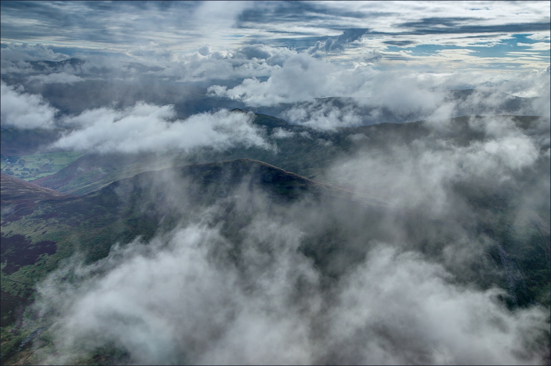
Clouds were moving quickly across the fell, and most of the final section was in mist

Boys will be boys, and Jason and James challenge each other to a race to the summit. I didn’t participate on the grounds that someone had to take the photo

We all got there in the end, and thanks to a fellow walker for this photo


We now set our sights on Hopegill Head, top right

We follow the path above Hobcarton Crags

There are two paths, the left hand one being more popular for obvious reasons

Just below the small summit of Hopegill Head and looking forward to our next destination - Whiteside

The cloud lifts and we can see the Hopegill Head to Whiteside ridge in all its glory

Ladyside Pike with Lorton to the left, and behind it Cockermouth, the Solway Firth and Scotland

James used the telephoto lens to take this photo of the Solway Firth and Criffel in Scotland, about 30 miles away

Further along the ridge

Grasmoor on our left

Heading towards Whiteside east top

Looking back to Hopegill Head

Our final destination is Lorton seen below, but before descending to Dodd we walk to the west summit of Whiteside further along the main ridge

Another view back to Hopegill Head as a quizzical Herdy eyes our progress…


Bonnie

Looking along Gasgale Gill to Crummock Water

Sweet Lorton Vale

Grasmoor from the west top of Whiteside

Coledale Hause and Gasgale Gill

Looking across Lorton Vale to Fellbarrow, with the Solway Firth beyond

Having returned to the east top, we’re now on the way down the Dodd ridge, and will turn right at a hause below Dodd

Low Fell and Fellbarrow on the far side of Lorton Vale

After crossing Hope Gill we head for Lorton

We turn right along the gated road for a short distance

We then follow the track through High Swinside Holiday Cottages, which enjoy wonderful views along the valley

The path to Scales

Boonbeck and High Lorton

Arriving in High Lorton

We pass by the village shop, and from here it’s a short stroll back to the start - what a great walk!
