
Route: Grasmoor, Wandope and Whiteless Pike
Area: North Western Lake District
Date of walk: 16th April 2021
Walkers: Andrew and James
Distance: 7.1 miles
Ascent: 2,900 feet
Weather: Mixed sunshine and cloud
We parked in the small car park at Cinderdale Common, from where the climb up the Lad Hows ridge starts immediately. It’s important to keep to the right of Cinderdale Beck, which is best forded at the very start. There is no respite from the ascent, though it’s fairly easy going until the last steepish section to the summit of Grasmoor, which seems to go on forever
The views from the summit of Grasmoor were superb and although it was rather hazy we could make out many of lakeland’s finest fells, including the Scafells looking south and the Helvellyn range looking east
We retraced our steps from the summit for a short distance and then descended to Wandope Moss. From here we made the easy ascent of Wandope. Although this constitutes a diversion from the path to Whiteless Pike, it’s only a 5 minute one. It’s a worthwhile diversion and there were more wonderful views from here
From Wandope we descended to Whiteless Edge, a narrow but safe ridge leading to the last summit of the day, Whiteless Pike
We then descended, quite steeply at times, to the junction at the head of Rannerdale. Having turned sharp right here it was an easy walk down High Rannerdale back to the start. The famous bluebells were coming into leaf, but won’t be in flower until May. To see photos of this spectacle click here. At the end of Rannerdale it was a simple short stroll back to Cinderdale Common
The weather was perfect for fellwalking today – sunshine, clouds and a cooling breeze on the tops helped to make this a special day
For other walks here, visit my Find Walks page and enter the name in the ‘Search site’ box
Click on the icon below for the route map (subscribers to OS Maps can view detailed maps of the route, visualise it in aerial 3D, and download the GPX file. Non-subscribers will see a base map)

Scroll down – or click on any photo to enlarge it and you can then view as a slideshow

We parked in the small car park at Cinderdale Common, next to this well known local sign

The sign is rather misleading - although it points towards Grasmoor the path is on the right of the beck, and the distance indicated is the longest 1.5 miles I've ever walked

We ford Cinderdale Beck beyond the car park and aim for the Lad Hows ridge on the right. The ridge is the key to the ascent, although the route isn't clear from here

James heads for Lad Hows

Rannerdale and Rannerdale Farm below, with Crummock Water beyond

Looking back along the path to Crummock Water and Loweswater

The route reveals itself, with the ridge to the summit curving round to the left

Looking back to Crummock Water and Mellbreak, its saddle like shape well seen from here

Rannerdale below - we'll be returning along there at the end of the walk

Rannerdale Knotts and Rannerdale Farm below

Rannerdale Farm

We reach Lad Hows, and continue up the path on the right

Looking back along the path to Crummock Water

The gradient steepens nearer the summit, though there are no difficulties

Another view back along the path

A hazy view of Great Gable and the Scafells in the distance

A steepish loose section near the top

Nearly there

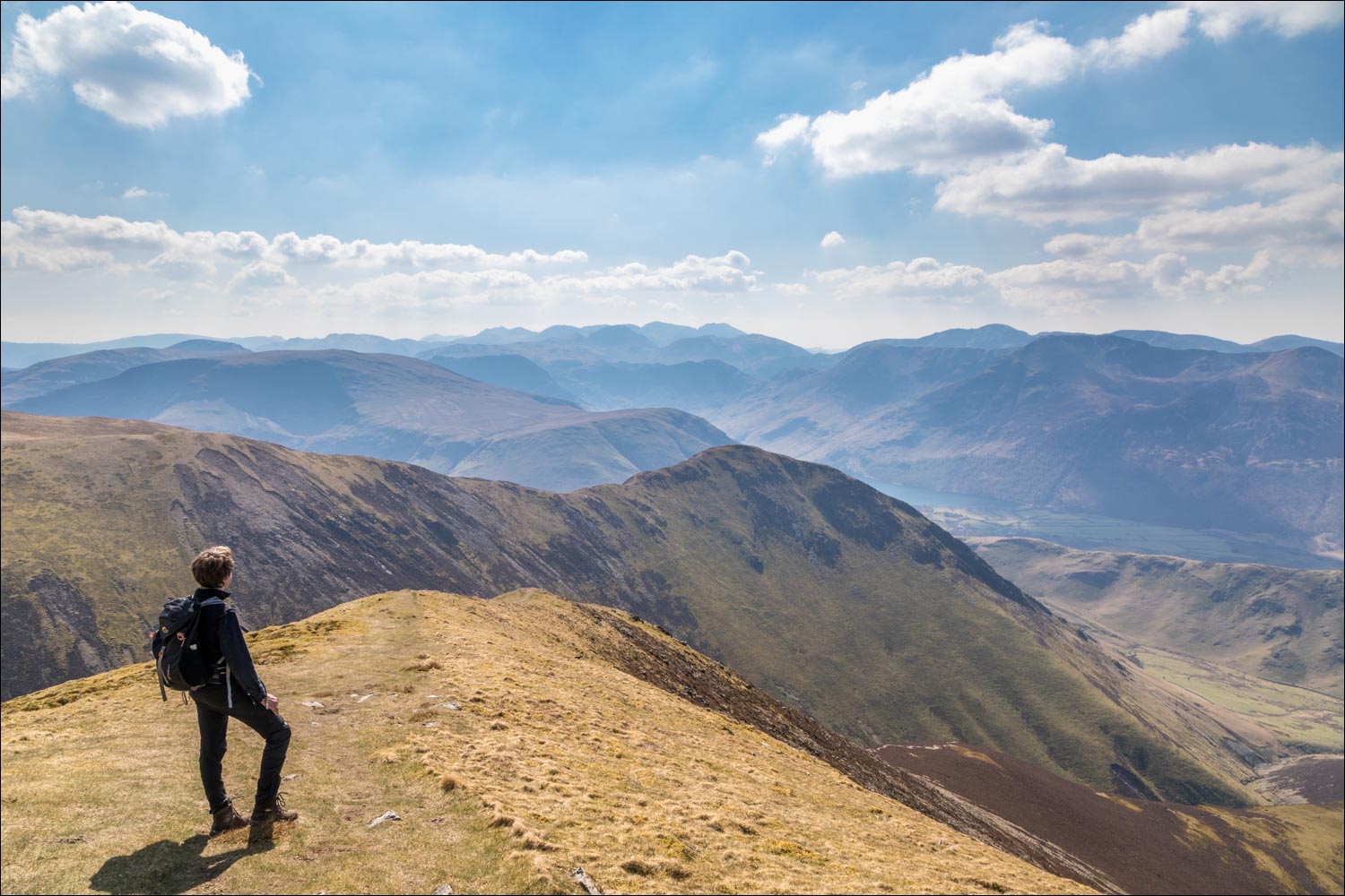
James admires the view from the summit area of Grasmoor. Whiteless Pike, the last fell on the round, is in the foreground

Rannerdale Farm and Crummock Water below

The summit area is a flat and rather featureless place, with a stone shelter at the highest point

View from another shelter closer to the edge - Whiteless Pike, Buttermere, Crummock Water and too many fells to list

A grassy stroll along the summit area in the direction of Crag Hill

Looking across to Hopegill Head and Grisedale Pike, with Skiddaw in the background

Dove Crags framing the ridge from Hopegill Head to Whiteside

We aim for a cairn which marks the end of the summit area of Grasmoor

We descend to the hause on Wandope Moss and will follow the diagonal path up to Wandope

Looking back to Grasmoor from Wandope Moss

From Wandope, looking east past Sail to Ard Crags

It's an easy descent from Wandope to the path leading to Whiteless Edge

Whiteless Edge and Whiteless Pike ahead...


Looking back to Grasmoor, left of picture

Crummock Water and Loweswater

We arrive at the summit of Whiteless Pike

Start of the descent to Whiteless Breast

Rannerdale, which will be our return route

We arrive at a junction and follow the path into Rannerdale

The path on our left leads to Buttermere

Rannerdale, and Grasmoor up on our right

Looking back along Rannerdale

Further along the valley

We arrive in the bluebell area and cross the footbridge over Squat Beck

The end of a wonderful walk is just around the corner

Early next morning, a brief visit to the head of Buttermere
