
Route: Elegug Stacks
Area: Wales, Pembrokeshire
Date of walk: 7th September 2019
Walkers: Andrew and Gilly
Distance: 12.0 miles
Ascent: 800 feet
Weather: Mixture of cloud and sunny intervals
Today’s walk was a long one, but it was worth the effort for the varied scenery we saw along the way. We parked in the National Trust car park in the small village of Bosherston and followed a path through the famous Lily Ponds, well worth a visit in their own right. We could have lingered here for much longer, as this is a wildlife haven and home to a wide variety of animal life, including otter and pike
After walking along the Lily Ponds, which occupy a large area, we arrived at Broad Haven beach, which looks out to the prominent formation of Church Rock. A stroll along the beach took us to some steps, which we climbed up to start the cliff top section of the walk. After 15 minutes or so we arrived at the steps which lead down to St Govan’s Chapel, an ancient hermit’s cell built into the rocks. According to legend the number of steps down is never the same as the number of steps back up. Gilly counted 74 going down and 75 back up, so it must be true
We continued along the cliff top, sometimes keeping to the main track and at others following paths closer to the cliff edge for better views of the scenery (take care, your best view could be your last). Eventually we arrived at our destination, the spectacular limestone rock pillars of Elegug Stacks and the huge rock arch known as the Green Bridge of Wales. After gazing in awe at these sights we retraced our steps back to the start, taking a shortcut near the end
It had been an exceptional walk, featuring the best cliff top scenery I’ve ever seen
Important note: much of the route lies within an MOD training area, which is in use for around 44 weeks a year, when access is prohibited. Weekends and holiday periods are generally free, but before setting off on this walk it’s necessary to ensure that there is unrestricted access. Recorded information is available by phoning 01646 662367 – we tried this but the message was incomprehensible. This link to the Castlemartin Firing Range is more useful
Click on the icon below for the route map (subscribers to OS Maps can view detailed maps of the route, visualise it in aerial 3D, and download the GPX file. Non-subscribers will see a base map)

Scroll down – or click on any photo to enlarge it and you can then view as a slideshow

St Michael and All Angels Church Bosherston at the start of today's walk

We follow a path beside the Bosherston Lily Ponds

The ponds were created between 1760 and 1840 and consist of three flooded limestone valleys

This is a wildlife haven, home to otters, bittern, kingfishers and many other creatures including 20 species of dragonfly

Looking back over the ponds

We were too late in the season to see the water lilies in flower- June is the best month


Beyond the final pond we arrive at Broad Haven beach

Well named Church Rock

We stroll across the deserted beach and head up the sand dunes on the far side

Looking back over the beach, with Church Rock on the right

Another view back as we reach the top of the cliffs

We arrive at Castlemartin Range - it's necessary to check in advance that the path is open, which it generally is at weekends

Looking back along the rugged coastline

An intrepid climber on the cliff face

Looking along the Pembrokeshire Coast Path in our direction of travel...


We arrive at St Govan's Chapel - the number of steps is said to vary depending on whether one is ascending or descending

There are various legends about this unique place, but Govan appears to have been an Irish abbot living in the 6th century. En route to Wales he was attacked by Irish pirates off the coast...

...he hid in a cave and turned the place into a hermitage, living there for the rest of his life. This is the view through his front window

Whatever the truth, it's a wonderful place

We climb back up the steps, counting a different number in accordance with the legend, and resume our walk along the cliff top. There are sheer drops below from some of the informal paths, but they may be avoided by keeping to the main path ...


Looking along the cliffs in our direction of travel

Looking back to one of the natural arches in the cliffs


The limestone cliff formations become more dramatic as we near the Elegug Stacks - a huge rock overhang...

...a deep hole - I didn't venture closer than this

Contorted rock formations...

Bullslaughter Bay


Flimston Bay...


Huntsman's Leap


We arrive at our destination - the spectacular Elegug Stacks...


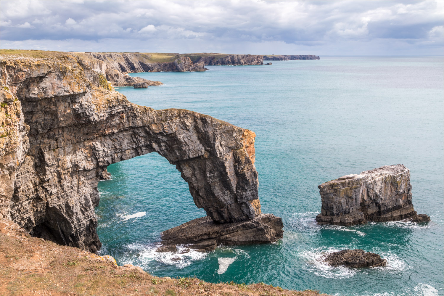
The Green Bridge of Wales, one of the finest natural rock arches in Europe...


This is the far point of our walk - it's possible to return via an inland route, but this is scenically less interesting and we preferred to retrace our steps


The Elegug Stacks again...


Zooming down to two grey seal pups in one of the coves

Adult seals

A final look along the cliffs before we head inland to follow a lane back to Bosherston

St Michael and All Angels Church Bosherston ahead, and the end of a fantastic walk
