
Route: Lulworth and Durdle Door
Area: Dorset
Date of walk: 6th August 2015
Walkers: Andrew and Gilly
Distance: 8.0 miles
Weather: Overcast at start but soon cleared, then sunny and warm
We parked in the main car park in the attractive village of West Lulworth and followed the wide track up the cliff, clearly visible from the car park. There were too many folk around for our liking but we guessed rightly that most of them would visit nearby Durdle Door and go no further. This proved to be the case
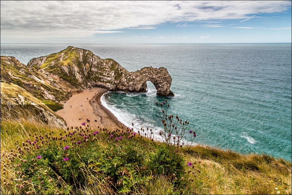
Durdle Door is a spectacular rock archway and a wonderful sight as we walked past it and continued along the cliff tops
It was a rollercoaster of a walk, with several big ups and downs and we climbed 1,700 feet in all – enough to get us up an average sized lakeland fell. The views were spectacular, especially so once the initial grey sky was replaced by sun and blue skies thanks to a strong breeze from the west
After passing by a navigation obelisk at West Bottom we turned inland and walked back to the start along the tops of the fields – the views from here were almost as good as those from the cliff tops, and it was a fabulous walk thanks to a combination of spectacular scenery and favourable weather
Click on the icon below for the route map (subscribers to OS Maps can view detailed maps of the route, visualise it in aerial 3D, and download the GPX file. Non-subscribers will see a base map)

Scroll down – or click on any photo to enlarge it and you can then view as a slideshow

The climbing starts as soon as we leave the car park in West Lulworth to join the procession heading for Durdle Door

Looking back down to the start

We follow the coastal path for the next 4 miles or so

St Oswald’s Bay

Durdle Door Arch, and Portland Bill in the distance

Looking back to St Oswald’s Bay

Bat’s Head protruding into the sea

Durdle Door again

Marbled White butterfly, one of many we saw along the way

Looking back to Durdle Door as blue sky starts to replace grey

The steep climb up Swyre Head

Looking back


Bat’s Head

Middle Bottom

Looking back up to Swyre Head

Portland in the distance

Gazing out to sea - or having a breather

Another view back towards Swyre Head

Having passed by the lower of two navigation obelisks, we head inland to start the return leg


Heading back to West Lulworth


Looking back

A caravan park in the distance increasingly detracted from the views looking forward

I’d guess this signpost has been photographed many times

Scratchy Bottom, which came 2nd in a poll for Britain’s worst place name (Shitterton won - or lost)

Approaching Newlands Farm, where we descend and have to walk through the caravan park mentioned earlier

An unexpected bonus as we passed through the park - baby swallows perched under the eaves of an outbuilding, waiting to be fed


West Lulworth ahead

Spectacular skies on this section of the walk…


Almost back to the start

We walked past the car park to visit the twisted rock formations of Stair Hole…

…and the remarkable circular Lulworth Cove

The mouth of the cove

When in Rome…
