
Route: Arnison Crag and Birks
Area: Eastern Lake District
Date of walk: 8th April 2022
Walkers: Andrew and Gilly
Distance: 5.0 miles
Ascent: 1,900 feet
Weather: Sunny, very cold on the tops
My walk up Place Fell one week ago gave me some good views of Birks and Arnison Crag, and reminded me that I’ve not been there for over five years. Coincidentally the starting place for today’s walk was the same as for Place Fell – outside the George Starkey Hut in Patterdale. There’s only room for about 8 cars there, and we were lucky that there was space available. There are other car parks in Patterdale in the event that this one is full
We walked along the road out of Patterdale, passing by the lovely little Church of St Patrick’s, and then turned off to follow the lane to Grisedale which is clearly signed. We left the lane at a gate and passed through another gate signed ‘Glenamara Park’. As we followed the path uphill there were ever improving views back over Ullswater and down into Grisedale. We arrived at Thornhow End and climbed quite steeply up to reach a flatter area with thrilling views ahead to some of Lakeland’s finest fells including St Sunday Crag, Dollywagon Pike, Nethermost Pike, Helvellyn and Catstycam. These higher fells were covered in snow, and looked majestic today
We continued uphill as far as a marshy area. The main path carries on to St Sunday Crag, but we turned sharp left here to make the easy ascent of Birks, which is a continuation of the St Sunday Crag ridge. From the summit of Birks there was a good view back to the Helvellyn range, and a slightly limited view of Ullswater. We descended from Birks to a depression at Trough Head, the key to our next target, Arnison Crag. We climbed up to gain the ridge and reached the summit of the fell after a short there and back ascent. The views over Ullswater are superb from here. We descended via Oxford Crag, following a path beside a dry stone wall, with more views of Ullswater ahead of us most of the way. The path brought us down to the Patterdale Hotel and from here it was a short stroll along the road back to the start
For other walks here, visit my Find Walks page and enter the name in the ‘Search site’ box
Click on the icon below for the route map (subscribers to OS Maps can view detailed maps of the route, visualise it in aerial 3D, and download the GPX file. Non-subscribers will see a base map)

Scroll down – or click on any photo to enlarge it and you can then view as a slideshow

View from the parking space looking to our joint objectives of Arnison Crag and Birks

We pass by the Church of St Patrick and a carpet of daffodils in its grounds

We turn off the Patterdale road to join the lane to Grisedale (there is a car park along the lane, current fee £5, but don't park on the lane itself)

We leave the lane here to join the path leading to Thornhow End, which we need to surmount in order to gain the ridge to Birks

Looking back to Keldas, with a glimpse of Ullswater

Place Fell, where I'd been last week

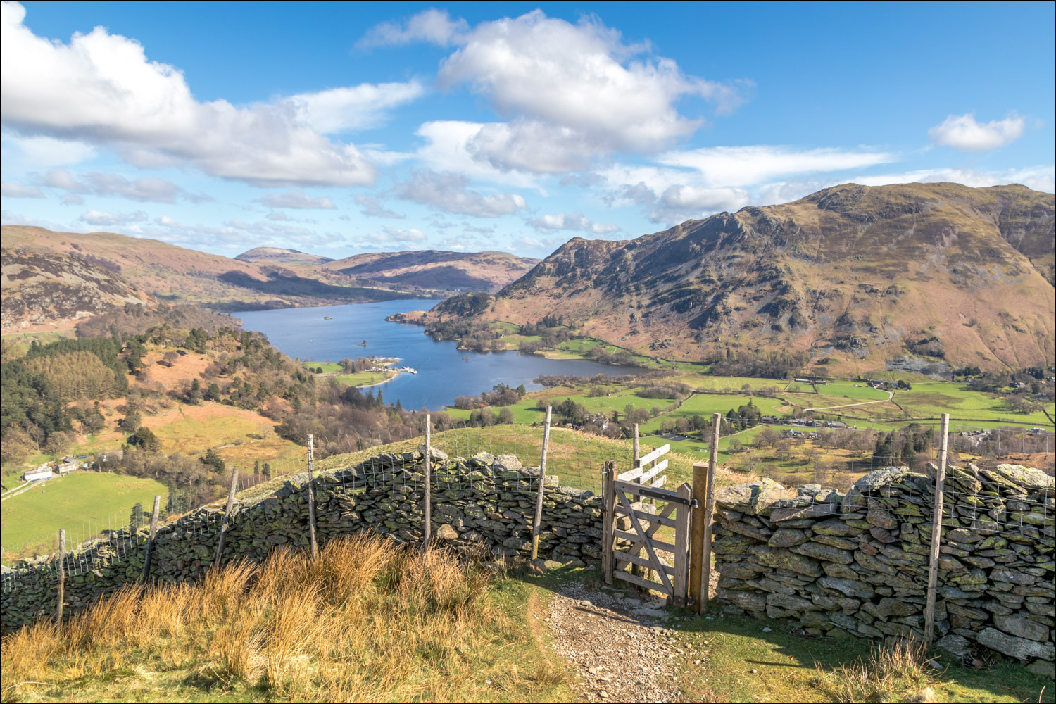
A view of Ullswater from Glenamara Park

Looking down into Grisedale, with the Helvellyn range coming into view...

We leave Glenamara Park to climb around Thornhow End

Ullswater from the other side of the gate

We climb up Thornhow End with a view of the Striding Edge ridge leading up to Helvellyn

Looking back to Ullswater and Place Fell

A wonderful section of the walk as the gradient eases above Thornhow End and we are treated to views of the eastern fells with a covering of snow. St Sunday Crag on the left...

Dollywagon Pike and Nethermost Pike

Looking back along the path

We continue uphill, with more views of the eastern fells...

A dry stone wall guides us down to Trough Head

We arrive back in Patterdale at the end of a wonderful walk

Patterdale below, on the right of the picture

Delightful views of Ullswater accompany us along the way...

We retrace our steps from the summit and join a path beside the dry stone wall, which will guide us down for most of the way

Ullswater from the summit of Arnison Crag

The summit of Arnison Crag is a rock platform, not accessible from every direction, but the ascent path is obvious on the ground

Summit of Arnison Crag ahead

A lone herdwick, with Hartsop in the background

We're now on the ridge leading to Arnison Crags, summit unseen from here

Looking back to Birks and the dry stone wall on the left which we'd followed during the descent

A short down and up at Trough Head

Arnison Crag mid picture

St Sunday Crag and Dollywagon Pike

Views of Hartsop and the far eastern fells as we descend to the ridge leading to Arnison Crags

The faint path is marked by a small pile of stones. 'Cairn' would be too grand a word for it. Arnison Crag is below

We continue along the ridge, but keep a sharp look out for a path on the right which lies just beyond these two rocks

An improbable dry stone wall looking across to Catstycam and the Hole in the Wall

We continue along the ridge, descending gently at first

We reach the summit of Birks which is marked with an insignificant cairn

Hartsop and its fells on our right

Ullswater from Birks

Looking back to St Sunday Crag

A change of scenery as we head along the easy ridge leading to Birks

St Sunday Crag ahead, but at its foot we'll change direction and turn sharp left
